![]()
Lake Champlain Basin Atlas
![]()
Lake Champlain Basin Atlas
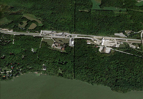
A six-meter-wide cut in the forest that marks the U.S.-Canada border near the Highgate border crossing in Vermont continues to the water’s edge on Missisquoi Bay. Image: Google Earth
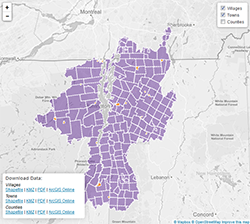
The landscapes of Lake Champlain’s far-reaching watershed lie within the boundaries of many political jurisdictions. The Basin spans the international border between Canada and the United States, and includes portions of the States of New York and Vermont and the Province of Québec. All or part of nine counties in Vermont and five counties in New York are contained within the Basin. Additionally, 239 municipalities are located within the Basin: 37 municipalities in Québec, 57 in New York, and 145 in Vermont.
As with all watersheds, the boundary of the Lake Champlain Basin is defined by the high points in the landscape that contain all the area that drains into the lake (visit the Watersheds & Tributaries page to view watershed maps). Political boundaries rarely coincide with watershed boundaries. For this reason, communication and coordination among the states, provinces, local municipalities, and federal agencies is essential to protecting and enhancing Lake Champlain for future generations. In addition to political entities, numerous individuals, not-for-profit organizations and private businesses play an important role in the management of Lake Champlain.
Students and Educators : Draw your own map of towns and counties! Visit the Blank Maps section of the Students and Educators page for “empty” maps.
The LCBP works across borders with many partners, including local municipalities, federal agencies, and non-profit organizations, to protect water quality and ecosystems in the Lake Champlain Basin.
Learn More→

The Champlain Valley National Heritage Partnership works to foster communications and collaboration across borders in order to protect the region’s rich cultural heritage.
Find out more →
© 2026 Lake Champlain Basin Program
LCBP is a program partner of
![]()