![]()
Lake Champlain Basin Atlas
![]()
Lake Champlain Basin Atlas
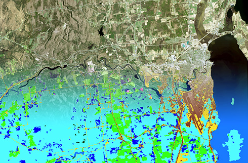
The view from above of the Plattsburgh, NY region reveals a variety of land cover types.
Seen from above, the Champlain Valley is a patchwork of land cover types. Farm fields, forests, suburban development, and a network of roads are stitched together into a tapestry of varying colors and textures. In the upper reaches of the watershed, a more consistent pattern of forest green is visible on the mountains and hillsides. Land cover is influenced by soils, geology, topography, climate, and human activities. From this perspective, land use is one of a number of factors that determine land cover we see from above.
Land cover and its underlying factors directly influence the condition of Lake Champlain, its tributaries, and other water bodies in the Basin. The impacts of human activities are sometimes obvious. The roles of impervious surfaces and agricultural lands as sources of phosphorus are well understood, but land cover in relatively undisturbed areas also determines conditions in the Lake. This is in part why the segments of the Lake are so distinct and require different management interventions.
Land cover data is created using satellite imagery and aerial photography. Through computer models and interpretation by humans, the different elements of the imagery are categorized into specific classes of land cover. Land cover data is an important element of many scientific studies. It is critical to water quality analyses and modelling efforts, such as Critical Source Area studies. The Vermont Agency of Natural Resource’s Clean Water Roadmap displays data about nonpoint source phosphorus loading to Lake Champlain from a variety of land cover types. Land cover data also can be used for a variety of other purposes, such as habitat analyses, riparian buffer identification, and land use planning.

The Lake Champlain watershed typically receives 35 inches of rain annually. What happens to precipitation when it runs off the landscape?
Learn More →

Phosphorus and other nutrients that affect water quality in Lake Champlain comes from a variety of land uses.
Learn more →
© 2026 Lake Champlain Basin Program
LCBP is a program partner of
![]()