![]()
Lake Champlain Basin Atlas
![]()
Lake Champlain Basin Atlas
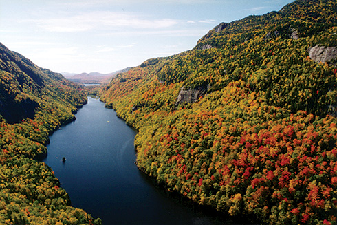
Lower Ausable Lake in New York’s Adirondack Mountains.
A watershed is all the area of land from which precipitation will run off into a particular lake, river, or body of water. Watersheds, or drainage basins, are defined by the high points that surround them. The Lake Champlain Basin is the entire drainage area for Lake Champlain. Rain, snow, sleet, or any precipitation that falls on the watershed will eventually reach the Lake and flow north to the Richelieu River and on to the St. Lawrence River and Atlantic Ocean.
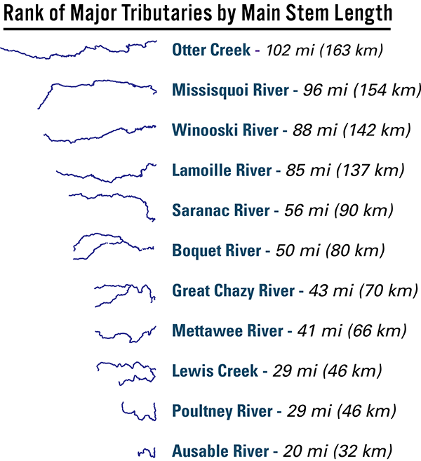
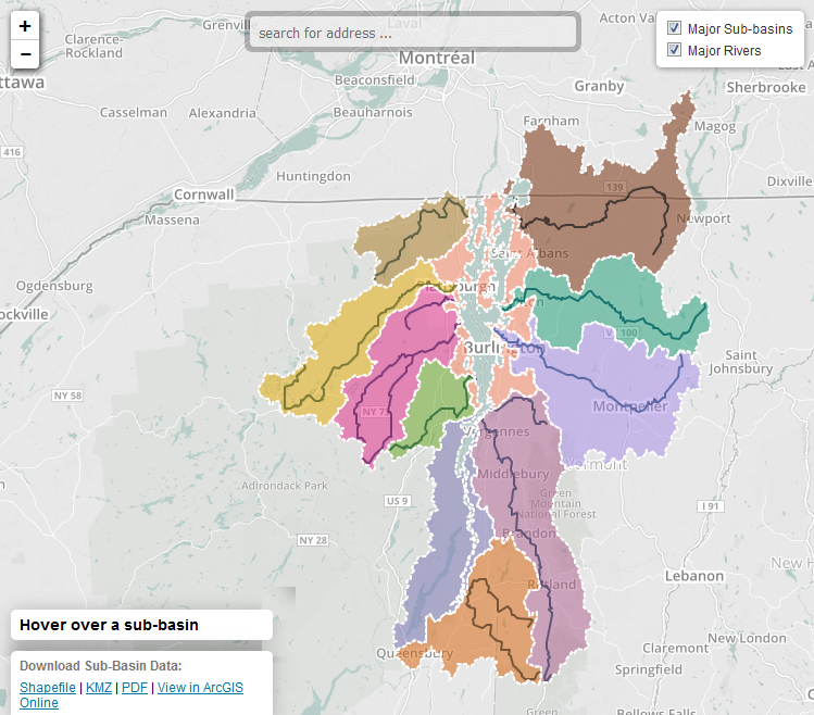
The Lake Champlain Basin can be divided into eleven major sub-basins, or watersheds, which are each drained by one or more of the Lake’s major tributaries. Since the first inhabitants arrived in the region thousands of years ago, Lake Champlain and the Basin’s major river corridors have been used for travel routes, agriculture, industry, and recreation. Today, these rivers are less significant as commercial arteries, but they are still the lifeblood of the Basin in terms of environmental health and many other benefits.
Download maps of individual sub-basins:
Some watersheds can be very large, encompassing vast river systems, or very small, defining minor tributaries. Larger watersheds often contain many smaller watersheds. Lake Champlain’s watershed is made up of many smaller watersheds that are defined by the numerous tributaries that flow into the major rivers that flow to Lake Champlain.
Scientists classify watersheds by size into designations called hydrological units. Each unit is uniquely identified by a series of numbers. This allows smaller watersheds to be identified within the larger watersheds. The larger the hydrological unit number, the smaller the watershed. For example, a HUC-8 (or eight-digit hydrologic unit) watershed can be comprised of a number of HUC-10 watersheds, which in turn are defined by any number of HUC-12 watersheds.
Classifying watersheds into hydrological units is useful for watershed planning and management. Watersheds are natural units of land, defined by a landscape’s topography, that are unconstrained by political boundaries. The Lake Champlain Basin Program commonly uses several groupings of watersheds in its research. The eight-digit hydrological unit is used in modeling the influence of major river systems, particularly in terms of land use and phosphorus loads. Eleven and fourteen digit watersheds are used for research which benefits from a more detailed examination of the landscape.
Compare the levels of HUC codes for the Lake Champlain Basin in the Hydrologic Unit Code Classification map.
Regional and local watershed organizations help restore and protect the Basin’s waters and ultimately Lake Champlain. These organizations rely on volunteers for everything from tree plantings to filing to public outreach.
Learn More →

The surface area of Lake Champlain’s watershed is 18 times greater than the Lake itself. All activities and land use in this area affects water quality.
Learn more →
© 2026 Lake Champlain Basin Program
LCBP is a program partner of
![]()