![]()
Lake Champlain Basin Atlas
![]()
Lake Champlain Basin Atlas
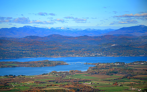
The Crown Point Bridge on Lake Champlain. Photo: Matt McCarthy
Lake Champlain is one of the largest freshwater lakes in the United States, with 435 square miles of surface area, more than 70 islands, 6.8 trillion gallons of water, and 587 miles of shoreline.
The Lake is unique, in part because of its narrow width (measuring only 12 miles at its widest point), great depth (some parts are more than 400 feet deep) and the size of the land area, or watershed, through which 90% of the water delivered to the Lake flows. The total area of the Lake Champlain Basin is 8,234 square miles, a significantly large watershed relative to the Lake’s surface area. About 56% of the Basin is in Vermont, 37% in New York, and 7% in Quebec. Visit the Lake Facts page for more statistics about Lake Champlain and its Basin.
The Lake flows northward from Whitehall, New York almost 120 miles, crossing the U.S. – Canadian border to its outlet at the Richelieu River in Québec. From there, the water joins the St. Lawrence River, which eventually drains into the Atlantic Ocean in the Gulf of St. Lawrence.
For much of its length, Lake Champlain defines the state border between Vermont and New York. Its watershed is bounded to the east by the Connecticut River Basin, and to the southwest by the Hudson River Basin, to which it is connected by the Champlain Canal.
Native Americans referred to the Lake by several names. The Mohawk called it Caniadari Guarunte, which means “lake with a bulge in it,” or “door of the country.” Abenakis are known to have used the name Bitawbagok, meaning “waters that lie between,” a reference to it being situated between two mountain ranges. After Samuel de Champlain’s exploration in 1609, the Lake became known as Lake Champlain to the region’s colonial settlers.
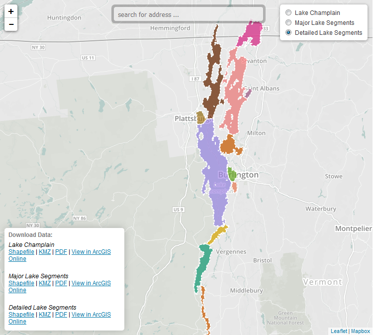
Unlike many lakes that are shaped like bowls and tend to be more evenly mixed, Lake Champlain is made up of distinct areas or lake segments, each with different physical, chemical, and ecological conditions. These thirteen segments are often used for scientific analysis or resource management purposes. For example, visit the Phosphorus Levels page to view phosphorus concentrations by lake segment.
Educators and students: Draw your own Lake Champlain Region map! Visit the Blank Maps section of the Student and Educator pages for an “empty” Lake Champlain Region map.
Lake Champlain was recognized as a resource of national significance by the United States Congress in 1990. Learn more interesting facts and figures about this “great” lake.
Learn More →

Every three years, the Lake Champlain Basin Program publishes the State of the Lake and Ecosystems Indicators Report. Most recently released in 2021, the report summarizes the condition of the Lake and understanding of the threats to its health.
Learn more →

Efforts to protect water quality in Lake Champlain are guided by the management plan Opportunities for Action.
Find out more →
© 2026 Lake Champlain Basin Program
LCBP is a program partner of
![]()