![]()
Lake Champlain Basin Atlas
![]()
Lake Champlain Basin Atlas
 Scientists track and analyze water quality conditions in 13 segments of Lake Champlain. Phosphorus concentrations in most of these segments are stable or increasing. Concentrations are highest in the far ends of the Lake—Missisquoi and St. Albans bays in the north and in the South Lake—where the water is shallow and often very warm in the summer. This combination of conditions—excessive nutrients, calm water, and warm water temperatures—is ideal for the growth of blue-green algae blooms. Concentrations in the Main Lake, which includes 65% of the total volume of the Lake, are slightly above the target, but are generally stable.
The charts in the “Phosphorus Concentrations” map show annual average phosphorus concentrations and the average total phosphorus concentration for the period from 1990-2014 for each segment. The phosphorus concentration target for each segment is also indicated by the horizontal line.
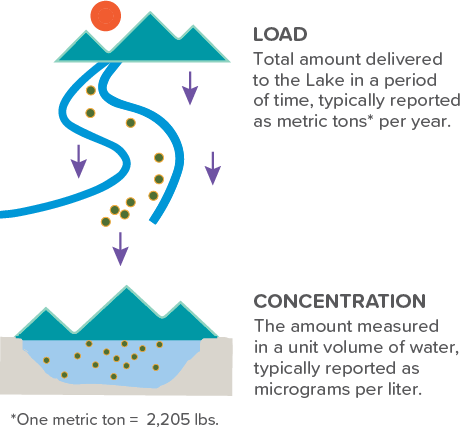
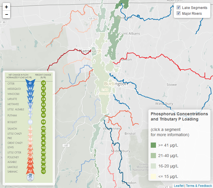
Most of the phosphorus that enters the Lake is delivered by tributary streams and rivers that drain the lands throughout the watershed. This phosphorus load from tributaries is estimated to be 921 metric tons (2.03 million lbs.) each year. Data collected by the LCBP’s Long Term Water Quality and Biological Monitoring Program has allowed scientists to calculate the loads delivered by each major tributary. Recent research shows that some efforts to reduce pollution are helping to reduce the loads delivered by the tributaries. The “Tributary P Loading” map shows changes in flow normalized loads (adjusted for variations in the amount of water that is delivered by the tributary from year to year).

Annual average phosphorus concentration by Lake segment.
In 1991, the states of New York and Vermont, the province of Québec and the US Environmental Protection Agency (US EPA) agreed to phosphorus concentration targets for each of the 13 segments. The targets for each segment are different. This reflects unique characteristics of the landscape in each segment, such as geology, soils, and vegetation, and the levels of phosphorus that would be expected to occur naturally. In order to reach these targets, New York and Vermont developed a Total Maximum Daily Load (TMDL) for phosphorus for the Lake. The TMDL is the amount of phosphorus the Lake Champlain can receive and still meet established targets. In 2016, the US EPA established a new TMDL for the Vermont portion of the watershed in an effort to reduce phosphorus pollution. The “Watersheds by Lake Segment” map shows the areas of the Basin that drain into each of the 13 lake segments.
© 2026 Lake Champlain Basin Program
LCBP is a program partner of
![]()